Like clockwork.
SURF:
Winter has been pretty much on track the past few months. Firing surf, some rain, then smaller sunny offshore days, and repeat. The past week was no exception as the swell slowly subsided and was replaced by clean conditions and sunshine. That means we’re due for bigger surf and wetter conditions- and wouldn’t you know it- that’s what we have on tap this weekend. Friday starts off small and clean then we have increasing S winds in the afternoon on Saturday as a new cold front approaches. We might see a small increase in NW swell late on Saturday but the S winds from the approaching storm will blow it to bits. Sunday looks to be windy from the WNW with overhead storm surf and showers in the AM. Basically it’s small Friday/Saturday and big/stormy Sunday. Water temps are holding at 60 degrees and tides this weekend are simple yet extreme. We basically have 2 tides at the opposite ends of the spectrum; 6′ at breakfast and -1′ late afternoon. For a more detailed THE Surf Report, check out http://northcountysurf.blogspot.com/.
FORECAST:
Monday cleans up as the cold front exits the region and we have a shoulder high sets. Tuesday backs off slightly to the chest high range then we get a building NW again on Wednesday- along with a stronger storm late in the day (it’s winter- what did you expect?)- for overhead bumpy surf by Thursday. Surf cleans up/drops next Friday/Saturday then models show a small chest high bump next Sunday the 13th. On it’s heels, the same models are showing a bomb of a storm between Japan and Hawaii which may give us double overhead surf again mid-January. We’re still 2 weeks out so take it with a grain of salt. But it looks like we’re at least in an active pattern in the near term.
WEATHER:
Get that yard work done on Saturday because Sunday will be messy. Not a big storm- a lot like the Xmas rains- but enough wind and rain to keep you in doors. Monday and Tuesday is clean and sunny but then a slightly larger storm is poised to arrive by late Wednesday into Thursday. Models can’t make up their minds with this one but we may get close to an inch of rain. Once that moves through, we should have good weather next weekend. Make sure to keep track of the waves and weather at http://twitter.com/NorthCountySurf.
BEST BET:
Most likely Monday with small clean surf as the bigger days on Sunday/Thursday will be met with rain. Or hold out until mid-month when the forecast charts show a doozy of swell arriving again.
NEWS OF THE WEEK:
Big fan of Hawaii? I am. Warm water. The 7 Mile Miracle. Don/Mason/Coco/Michael/Derek Ho. Shave ice. Ted’s Bakery. More fun than you can shaka stick at. Never been? Better hurry – a team of researchers from the University of Hawai’i at Mānoa (UH Mānoa) and the Hawai’i Department of Land and Natural Resources (DLNR) determined that land area in Hawai’i vulnerable to future sea level rise may be double previous estimates. Woops. Here’s what their findings in the Nature journal, Scientific Reports recently published:
“The bathtub method (a widely-used approach for assessing impacts of sea level rise where the ocean surface is projected onto a terrain model) provides a good first look at low-lying flood-prone areas but underestimates the full extent of potential damage due to sea level rise, particularly on Hawaii’s high-energy coasts,” said lead researcher Tiffany Anderson, a faculty member in the Department of Earth Sciences at the UH Mānoa School of Ocean and Earth Science and Technology (SOEST).
As sea level rises, several processes are at work- coastal erosion results in permanent land loss but is also essential for preserving beaches; annual wave flooding rapidly escalates past a critical point; groundwater inundation and storm-drain back flow create new wetlands and cause urban flooding. These render coastal armoring insufficient as an adaptation strategy.
“Our more comprehensive assessment reveals important realities that can be overlooked with other methods. Critically, the “bathtub” approach, alone, ignores 35-54 percent of the total land area exposed to one or more of these hazards, depending on location and SLR scenario,” said Chip Fletcher, co-author of the study and associate dean and earth sciences professor at SOEST.
The team also found that typical elevations of Hawaii’s low-lying coastal plains create thresholds of flood levels, above which rapid increases in flooding occur. As sea level rises, coastal lands are exposed to higher flood depths and water velocities. The prevalence of low-lying coastal plains leads to a rapid increase in land exposure to hazards when sea level exceeds a critical elevation of about 1 to 2 feet, depending on location. The team had identified this phenomenon in previous research and named it a “critical point.”
“Additionally, a large portion of lands at risk of flooding are not in direct proximity to the shoreline,” said Anderson. “Instead, they are low-lying areas where sea level rise causes the groundwater table to rise up to the surface. These areas can be located one to two miles inland from the coastline.”
“It’s important that we identify land areas vulnerable to sea level-related hazards because, if left unmanaged, flooding, wave inundation, and erosion will continue to encroach upon coastal lands that are typically heavily developed,” said Fletcher. “Preparing for these effects will be very costly and take a long time to implement. With these results, stakeholders of all types are now able to establish empirically-based adaptation policies.”
The modeling presented in this study was conducted to support the creation of the Hawai’i Sea Level Rise Vulnerability and Adaptation Report, which is the basis for further government planning initiatives.
“We can always count on these researchers at SOEST to provide the State with cutting edge research and modeling to improve our understanding of coastal hazards,” said Sam Lemmo, study co-author and DLNR administrator. “Their work is immediately translatable to policy and regulatory guidance at the local level. Our goal was to create a scientifically rigorous visual tool to highlight the gravity of sea level rise in our islands to prepare our communities and government bodies for its impact, as well as to provide tools necessary to reduce the shock to our socio-economic system.”
Anderson and team are currently incorporating rainfall into the computer model to determine how sea level-related flooding might be exacerbated during rainfall events that occur during high tides. Hawai’i Sea Grant, also located at UH SOEST, and Tetra Tech, Inc. are helping guide State and county agencies in considering this new data in future planning.
So if you haven’t booked your ticket yet to Hawaii for the summer- do it now.
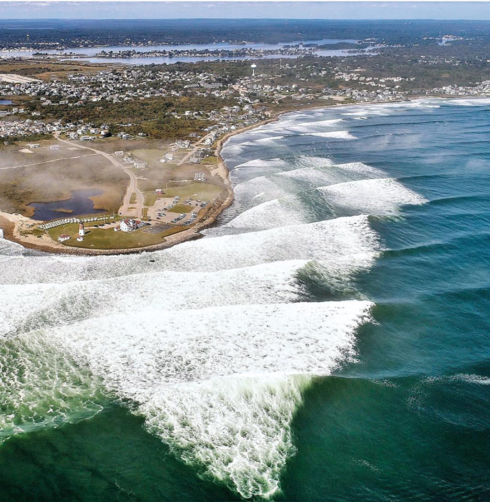
PIC OF THE WEEK:
I’d tell you where this is but I don’t to expose this secret spot in R#0d3 15!@nd.
Keep Surfing,
Michael W. Glenn
Plays Well With Others
Maxed Out My Black Card
Completed My A to Z Bucket List And Surfed Every Spot From Anglet to Zippers